Air Quality Models (AQMs)
- Advanced numerical air quality models (AQMs) are developed to understand the interactions among meteorology, emissions (both manmade and biogenic), and pollutant chemistry and dynamics.
- Air quality models are used for a number of purposes:
· Air quality management and reduction plan development
· Research on improved modeling methods and inputs
· And most recently for air quality forecasting
- Following air quality models are the most used chemical transport models worldwide:
· Community Multiscale Air Quality (CMAQ) modeling system
· Comprehensive Air Quality Model, with Extensions (CAMx)
- To use these chemical transport models, number of inputs should be prepared for the study region.

Emission rates, the most important input of AQMs
- Emissions data are one of the most important inputs for air quality models.
- Emission input files are generated from data provided by emission inventories.
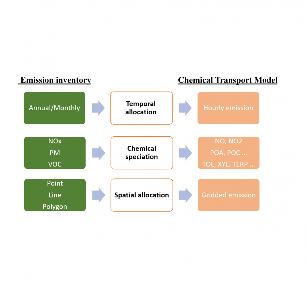
- Emission inventories:
· Are typically available with an annual/month-total emissions value for each emissions source, or perhaps with an average-day emissions value
· Are prepared in terms of regulated pollutants such as carbon monoxide (CO), nitrogen oxides (NOx), volatile organic compounds (VOC), and particulate matter (PM)
· And are available at the location of pollution source (point, line, area)
- The AQMs, however, typically require:
· Emissions data on an hourly basis
· For each model grid cell (and perhaps model layer)
· And for each model species
- Some inventory pollutants exactly correspond to a single model species (e.g., CO) but most inventory pollutants correspond to several model species, e.g., inventory pollutant NOx corresponds to model species NO and NO2.
- Consequently, emissions processing is needed to transform an emission inventory through temporal allocation, chemical speciation, and spatial allocation, to achieve the input requirements of the AQM.
- These needs require a computationally efficient, user-friendly, and flexible emissions data processing system.
What can CEMIGEN do?
- The purpose of CEMIGEN is to convert the emission inventory data to the format needed by an air quality models (CMAQ & CAMx).
- It is a JAVA-based system that is computationally efficient and flexible.
- CEMIGEN perform following processes on emission inventory data:
· Translate emission inventory pollutants to CTM emission input species using split factors that allocate inventory pollutants (e.g., VOC, PM2.5) to model species (e.g., formaldehyde as part of VOC, elemental carbon as part of PM2.5).
· Perform functions similar to Geographic Information Systems (GIS), for mapping emissions sources to CTM modeling domains.
· Convert annual and monthly emissions into hourly emission needed by AQMs using temporal profiles imported by user.
· Produce hourly, gridded and speciated emission file in the format needed by CMAQ and CAMx.

Main CEMIGEN inputs
- Yearly/monthly source emission data in CSV format
- Source location in GIS industry standard ESRI shapefile format
- Chemical speciation profiles to convert emission inventory pollutants (e.g., NOx, VOC, PM2.5) to model species
- Temporal (Monthly/daily/hourly) profiles for each source
- Domain configuration
- Holiday information